Thursday, September 30, 2010

model 3


Contradiction to the title but this is the first model. To summarize, this models reflects not only the painted diagram but shows the circular experience of a continuation of commuting over the Bay Bridge, you have suggest the point of intersection be the toll if you want. The infinity symbol is to represent the path of travel in moderation, and the paths that leads astray is the exit. Since every directions is directed by the passenger they decide which path to take. Each path is directed to a street or main street to that went they exit the building that they wont be bombarded by a building.
The highest path or section of the building will be the residential to capture the best views of SF business district. The galleries will be below them as it is connected to the pathway of the cinemas. In addition to the residential being on the top floor is to frame the tallest building on the site, the names escapes me. Also the arrangement of this infinity is to reflect of the orientation of site buildings.

Model 2


This particular model is a variation of my wooden model. Due to the lack of sqare footage.

I wanted to have this fluidity to represent this endless motion within the structure. This form was generated by expression of directionality, I believe I have gotten carried away a little bit. The circulation but have become to abstract. However I wanted to convey that experience of traveling from point A to point B should not be dull. I guess this floor plan is more of a mall that anything to start with. The large circle area is the center point, this is the collection of which the SF slaves are gathered to work, as the darkness comes that release themselves and disburses in an array of directions.
My wooden model focus on the infinity of endless travel encompassing the morning experience, this captures the night experience of leaving SF instead of coming too. Program, the large focal center is for galleries to make us of the lighting for natural lighting and ventilation, the smaller circle which is covered is the cinemas held within an enclosure, and the railing that protrudes to the front of the main structure is like a disconnect form work is the residential.

Case Model 1


This model's concept is about City Car Share, the process of which a single car is shared among several people, during each encounter, a cluster is formed, these cluster are represented in mass form, and these forms will be determined as program space. The lines that are randomly placed caters to the existence of the free form. Used as a structural element, curtain lines carries two functions, one being a catwalk that may lead to another building or a platform/balcony. And some lines are used as structure.

The larger mass program is the cinemas, then the galleries in the middle and residential on the far left. The model is positioned slighted on the site to create the maximum exposure and views.

Skateboarding, space and the city: architecture and the body By Iain Borden

http://books.google.com/books?id=vWWWfp_22DQC&pg=PA250&lpg=PA250&dq=skateboarding+v+architecture&source=bl&ots=XiVQ1EjPXN&sig=voLNbEzeI5TcVkArb0IftHJEhf4&hl=en&ei=MeKkTNvxI4ycsQO-0oH-Dg&sa=X&oi=book_result&ct=result&resnum=1&ved=0CBkQ6AEwAA#v=onepage&q&f=false

Monday, September 27, 2010

Soundscapes

For those of you working on sound - this may be useful:

http://www.aiasf.org/Programs/Public_Programs/Architecture_and_the_City/tours.htm#soundscapes

DIAGRAMS

Organizing what IT could be.
Layering information.
Resolved and unresolved issues leaving space for more conceptual growth.
Understanding liminalities.

INVESTIGATIONAL & OPEN TO CHANGE


Thursday, September 23, 2010

Zero th

This association was something shown to me a few years ago and I'm just now remembering it. There are most likely a couple projects in here that will be benifitial to more then a few of us if you take the time to review the site and their work. The ones that come to mind first are "hinge dimension" and "kontakt" But basically Zero Th is an architectural association interested in space & time.

http://www.zero-th.org/

Wednesday, September 22, 2010

Mapping


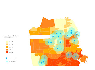
The first of image is to show the extrusion and manipulation of space through a data set. Broadly thinking about how quantifiable data can be transformed into a visual form. While the second and third images utilize the created visual information to influence the alignment and spacial relationships in comparision to that orientation.

Transformational Form

A blog documenting the design of a transformable structure:

http://arch501.wordpress.com/teams/process-book/tbj/

Saturday, September 18, 2010

Linear Mapping / Diagramming

For those interested the artist Ward Shelley is, in my opinion, an interesting example for linear mapping.


Wednesday, September 15, 2010

Sunday, September 12, 2010

3D Site Model

We have an in-progress 3d site model on archshare. Located in the ARH608 folder, labelled "final final site model". You can use it for the 3-d mapping.

Saturday, September 11, 2010

Mapping Extracts

Some interesting studies I have seen to date, and some possibilities for their use (I may be stretching these a bit):

Extracts: Graffiti Art, Graffiti Artists, Spatial Qualities
Plotting: The interaction between different types of graffiti, various populations artists and otherwise, and the spatial characteristics in which each of these are found.

Extracts: Foreclosures, Income Levels, Renters and Owners
Plotting: Relationships between income levels and rate of foreclosure, this might be layered with new home purchases and home flips to display developers taking advantage of the foreclosure market.

Extracts: Art House Theaters, Films, and Patrons

Extracts: Food consumption, food production, lines of transit

Extracts: Sources of pollution, cases of asthma, income levels

Extracts: Bicycle (or skateboarding) Networks, Urban Spatial Qualities

Extracts: Tourist Destinations, Crime Occurrences, Human Reaction / Activity

Keep in mind that this is not everything, but just a few of the things that I've heard over the last few days...

ArcGIS Viewer


Here is a screenshot from ArcExplorer software (click to enlarge), a free GIS data viewing program that is very easy to use. I have uploaded it to the course website for you to test.

This particular data set is bicycle networks in San Fransicso. There are endless amounts of data available on the SF.gov website and elsewhere:

http://www.esri.com/apps/products/download/index.cfm?fuseaction=download.all


http://gispub02.sfgov.org/website/sfshare/index2.asp

Prada Transformer Art Architecture Film Fashion 2009.

Robotic architecture

Friday, September 10, 2010

Mapping inspirations

some crazy-code-emotional generators!


Talking about mapping and form generating ideas, i found this software >>Synesketch<< that generates graphics based on code. Pretty much it takes words and translates them in to animated visual patterns, taking in consideration the emotion of words! Very interesting concept in case u have some time to kill, here is the website
ALSO! going down the artistic pathway there is this Argentinian artist Guillermo Kuitca who is mostly known for mapping. one of his collections "Diarios" where he mapped his life since 1994.


some interesting comments about maps: “to get lost… not to get oriented.” “the way they occupy a space somewhere between the abstract and the representational.”

If you check out his website: ( Guillermo Kuitca ) you can see all his earlier work which is very interesting too.

Thursday, September 9, 2010

Spatialkey

While the studio is still tackling issues of mapping and methods of analysis it might be advantageous to look into a studio account on Spatialkey. It's a website previous architectural professors have used to initiate and provide a starting point for those who are having problems with mapping or simply want to try various methods of mapping.

Spatialkey is a website that takes gathered numeric data that you've uploaded and applies it in a visual manner using various forms and techniques. Also utilizing the web to pull visual information from it that is applicable to your gathered data.

www.Spatialkey.com for anyone interested and if it's mentioned in class as something potentially helpful then so be it.

Monday, September 6, 2010

The Agency of Mappings

Mapping looked at in broad terms defines topography, urban construction, quantifiable statistics, spatial and geographical boundaries. An in-depth look however reveals complexity within the map such as political, socio-economical, historical and environmental patterns. But because mapping is taken for its literal quality, in what a map displays instead of waht it represents, the true valu and creative aspect of a map is repressed. In conjunction with mapping techniques as well as the increase in technology, mapping can play a more creative role in urban desgin. As we advance culturally and technologically, mapping will play a part in describing changes and revelations hidden within our own 'Known universe'.


Rincon hill area plan, linked below.
http://www.sf-planning.org/Modules/ShowDocument.aspx?documentid=2511

Transbay Transit Center


http://temporaryterminal.org/

The new transit center project designed by PCPA at first and mission is covering from mission st. to folsom st., connecting eight Bay Area counties and the State of California through 11 transit systems: AC Transit, BART, Caltrain, Golden Gate Transit, Greyhound, Muni, SamTrans, WestCAT Lynx, Amtrak, Paratransit and future High Speed Rail from San Francisco to Los Angeles/Anaheim

there're useful informations on the TJPA website